Good for kids
Yes
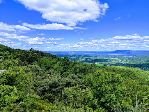
Schunnemunk Mountain State Park in New Windsor


Categories
Location on the map
New Windsor, Orange County, New York, US
Amenities
Comments (194)
Really strenuous hike, but great views from several lookouts! Sweet clover trail thru field needs help, not well marked. I ended up going Jessup trail (yellow) up, then took Sweet clover trail (white) down. Walked thru the tall grass, no ticks, but a huge praying mantis crawled up my shirt...is that good luck?
What a unique area to hike in. Lots of concretions under your feet, scrub pines and scrub oaks. Just beautiful.
Great hike, but the trails need work between the two ridges. Hiking solo, you will need to know the trail routes pretty well to avoid getting lost, there are many unmarked paths, and the valley between the ridges is quite steep and rocky following the orange and white trails, along with the Long Path. Its easy to get off trail here, given the distance between blazes and the often unclear path. Using a map reader, such as Avenza couldnt be more helpful here. All in all, I enjoyed my hike, despite the difficulty i found navigating the trails.
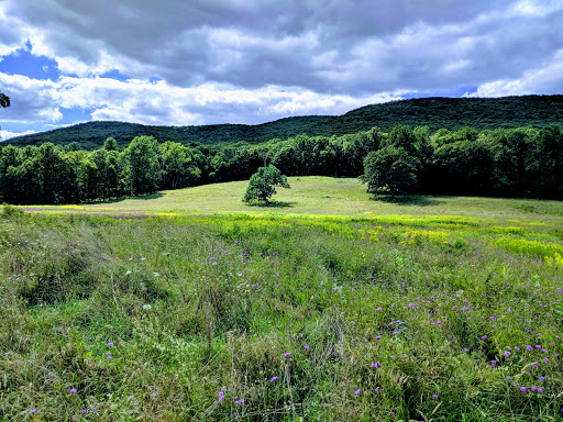
Its a great place to take a nice, easy hike with a mild upgrade and beautiful trees with a view of the creek.
Great hike with lots of trails, vistas and a beautiful pitch pine forest up top. Wear sturdy shoes and bring a lot of water.
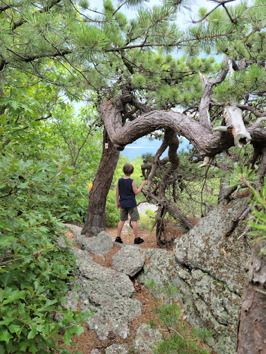
The monoliths are a must see if you have time for a semi rugged 3.5 hour hike. Probably not good for elderly or young kids, but my pooch had a blast and we had some amazing views
Nice short hike to OCs tallest mtn. Some off season views, quasi-well maintained trails. Perfect day hike that gets you right to work (start at trestle and veer right to white trail. Bring bug spray, camera, and water. One could get away with just sneakers however hiking boots/shoes always make for an easier and better time at any incline.
Nice but the trail markers are abysmally bad in some places. I highly recommend downloading Avenza along with the free map for the park to help you stay on course.
Always a beautiful place to hike!
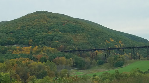
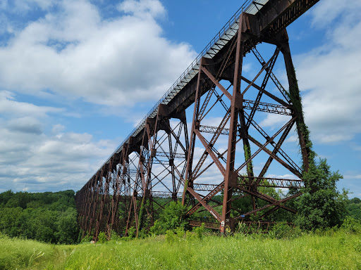
Ive walked some of the roads in the area. A friendly stranger walked me to one of the trailhead, but with vultures lurking about, I decided to keep to the roads. Last week I rode my bike from my house to the Schunnemunk Mountain area and back. Along the way, there was a beautiful view of the Moodna Viaduct (train trestle).
Great hiking trails and views!
It is definitely a great place to hike. Beautiful scenery. You can take your dogs here which is nice. It is mostly a hike on an incline so make sure you have plenty of water. Itll take you about 2 hours to finish the elite hike.
Beautiful park with well marked blazeons. Excellent vies and challenging climb.
Views are beautiful, trails can be tough on some places!
A great hike with a bit of a rock scramble. Lovely views of the Hudson River and Highlands.
Great hike. Beautiful views. Took around 4 hours, and we hiked around 7 miles.
So beautiful, hot, and humid. Love the changes in terrain.
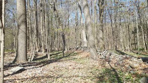
Very nice hiking. Be careful with the conglomerate rocks which are very slippery if slightly wet. Trails are well marked, and there was an ample supply of maps at the Otterkill Road Trail Head. Some nice streams and small waterfalls.
My sister and I hiked up the sweet clover (white) trail and came back down the jessop (yellow) trail. About a 6 mile hike. The trails were absolutely beautiful and well marked and the streams were flowing nicely throughout the park, so lots of great little waterfalls everywhere. I would definitely suggest bringing a map with you though as there is no distinction besides the color markers on the trail to tell you which path is which. There were a lot of trees down across the trail but Im sure those will be cleared out soon enough. All in all a great hike. Id give it a 7/10 difficulty for those new to hiking.
This is a great hike with scenic vistas and plenty of options. The first mile or so is challenging uphill grade but then levels off somewhat. Love the megaliths
Beautiful views on well maintenance trails. The top of the mountain is amazing, the Flora is pretty unique up there with higher elevation pine trees and exposed rock that is great for sitting and enjoying the views!
Its serene in winter. There was just the right amount of snow so the entire scenery was covered in a pristine blanket of white. Streams had frozen over, melted, and frozen again but there were spots where a small stream would flow, lending the atmosphere with that soothing sound of flowing water thats so relaxing.The rocks at the top are very beautiful and so are the cairns.Driving is the only way to get here, however. There are restaurants about 7 miles away.
Love it out here I find something new everytime I come and the is ever type of trail to follow from just a leisure hike to the more advanced trekkers. There is even a are for hinting here though Im not sure if there is camping allowed but I plan on looking into it. Every manner of wildlife as well can be found out here throughout the year
Challenging hike options up to two ridgelines with grand vistas. The rocks underfoot (purple puddingstone) are very grippy; however, at the lower elevations in November, the path is covered thickly with leaves that are a bit slippery even when dry. Walking sticks help.
The views were great! Would do another hike here again
Its a pretty steep killer hike. Bring plenty of water if youre hiking in mid August. Some rattlesnakes but they wont bother you. Awesome place to hike.
Fantastic scenery, both easy & challenging hiking trails.well worth a visit.
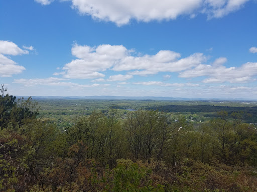
Amazing place! Where do I start? First - location. Schunemunk is the most prominent hill in the area - means the views are countless: Central Valley, Hudson, Moodna Viaduct, surrounding hills. All you need is a good weather. Being in a good shape doesnt hurt as well - climb to Schunemunk is pretty strenuous (and descent is not much easier, especially via Long Path). There are so many hiking opportunities - it may take a couple days to cover everything.
Beautiful views once you reach the vista! We followed the white trail - intermediate level hike.
Nice marked trails, not to much other than the regular mountain view as you hike and its almost all up hill :)
Love going to this place when ever I get a chance. The views are the best. The trails are fun. Will be back soon.
This is a hard hike... but the rewards are stunning views! Also its the tallest peak in Orange county
Amazing experience with a great view.
Amazing place for those with little or none hiking experience, I would describe as a 4/10 in difficulty, definitely would recommend to those who had just started such strenuous activities.
Very nice hikes, the trails are very well marked and well kept. Highly advise for moderate hikes. Steep in some places
Great place for a hike
The hills and climbing will kill you.. but when you get all the way to the top the view is amazing! Theres also a lot of Rose Quartz at the top of the mountains❤
Great place to hike with fantastic views. Careful on the yellow trail to the JS/OK intersection. That section of trail isnt marked as clearly.
Tough walking, loose stones, steep grade. Exactly what I thought it would be and the work out I was looking forward to. Great hike and nice lookouts.
One of the newest NY State Parks, with moderate trails, decently marked, with a small parking lot and just a train map
Very nicely maintained and quiet trails! Not nearly as crowded and bear mountain, storm king, or minnewaska. Nice views at the top.
We where very disappointed. The Park do not has groomed hiking trails and no sings .Very hard to find your way. Tall grass covers the way.
Great place to hike and xc ski. Go early to avoid the crowds.
Wonderful hike! Not to bad, little steep but pretty easy going
Schunnemunk has some of my favorite summits, but above all its a local secret. Everybody coming up from the city goes to Bear Mountain and Storm King... The New Paltz kids do Minnewaska. Schunnemunk is just for us, so go and enjoy it!!
Amazing views of the area from atop the ridges - some steep parts but definitely worth it.
Great trails. Quiet. And great views. Needs more wildlife to run from. Kidding.
AWESOME ! The whole fall valley colors are just about ripe. Take the whole family, or a nice personal walk. ENJOY !!!!
Great hiking trails, but it’s easy to get lost so bring a map.
One of my favorite places. It is absolutely beautiful. Nice place to take the dog for a relaxing walk.
Beautiful place for a hike, views are amazing, not very crowded
Nice hike and decent views, but its super easy to get lost here
Awesome views, almost 360 degrees at some spots along the south ridge. Trails connecting the north and south ridges have some scrambles.
Nice hiking trails, not the best for running. A bit muddy, need trail running shoes next time.
Very beautiful views from the top, 6 different trails, pretty intense.
Incredible views, and great hiking trails which are moderate difficulty.
Big park with lots of views and intresting places you can only find if u explore for yourself
Good moderate hike....nice trails but poorly marked....hard to follow different trails.
Enjoyed the trails, everything is well marked. Lots of elevation.
Great place to walk the dogs on a fire road or very challenging trails if that is what you seek.
Lots of trails. Beautiful views if youre up for the climbs.
The BEST venue ever! The friendliest staff and volunteers! Home of the Midnight Rambles for many years! Keep it going!
Great hiking. Wish the trails were less overgrown
Lovely views
Beautiful views. Going to come back in Spring to seethe differences.
This hiking area is amazing. Definitely coming back for more!
Just passing along and wanted to enjoy the scenery, very nice and peaceful right along the highway.
Great hike. Easy. Beautiful views...
Love hiking here not strenuous easy for beginning of the season
Google maps directed me to a church.. There were kids playing and it appeared to be a private residence.
Great trail to test your Cardio with a great view at the top!
Schunnemunk is a gnarly little mountain with a variety of challenging trails with great Vistas
Awesome day hiking. Best views in O.C.
Spending time with family.. its beautiful out here n peaceful very relaxing
Great hiking with beautiful views.
Great hiking!
I love this place. It offers great views. It is not crowded.
Well maintained trails and it had a natural feel to nature
Variety of terrain, great views, great hiking.
Beautiful views at the top, easily accessible, not crowded. Whats not to love?
Great views good food all included in one price great getaway
Open view, great trails, kids loved the bridge
Good hike. Challenging. Pretty views
One of the best hikes around the city
Beautiful
There be monsters here.
Tallest peak in Orange county. Beautiful in every season.
Service was little slow but food was great. Good happy hours prices and very friendly staff
Great for hiking or hika biking. Not for beginners.
Beautiful hikes and loops from base to peak
Very cool hike close to NYC.
One of the better hikes in the Hudson Valley.
I finally see why my work colleague loves this place so much. Hike it yourself and find out.
Watch out for the train. Beautiful hike.
Just an all-out beautiful place to just sit and sit and sit and relax
Great hiking views
What a beautiful place to visit or hike.
Great hiking spot
Fun clean hike
Mountain is too big, so many trail heads.
Hudson valley has so many hidden gem hikes
Legendary
Great place to snowshoe and hike
Fun hike
Challenging hike, Great views.
Relaxing, peaceful, nice weather, nice views.
Great hiking location.
Rustic and real...endless trail options
Watched a work train cross the Moodna.... Rad as heck
Great place for hiking
Definitely worth a hike!
Fun well marked trails?
Was a lot better before state took it over
Beautiful grounds to hike
Back to nature good exercise getting to the top!!!
Good for walking the dogs and jacking deer.
Awesome hiking spot
Great corporate offices and meeting place
I didnt find nothing
NIce climb
Quiet, peaceful, easy to navigate.
Awesome really love this place👍
Great hiking.
Fun place to hike
It was a nice walk in the woods
Nice quiet hiking
Nice view
Good view
Warning!# Rattle snake heaven
Cool little spot.
Great trails
Its a mountain, a pile of rocks
The posted pictures sya it all.
We love it here !
U have to go your gonna be amazed
Nice place to take a break
The most beatiufulness view.
Beautiful views.
Vast, green and isolating.
Stunning place
It’s cool!
Relax and very interested
Beautiful view
Beautiful view
A great day!
Nice park.
Love the sights
Beautiful
Beautiful
Beautiful
Beautiful
Nice
Beautiful
Beautiful
Absolutely beautiful
Cool
Great views
Pretty
Beautiful park
Uhh
Nice vew..
Enjoyed
Beautiful
Nice views
Absolutely wonderful
Beautiful scenery
Always beautiful.
Pretty scenery
Absolutely amazing
Beautiful place
Great service
Hilly
Nice place!
Love the place
I was passing through
Beautiful place
Picturesque
Beautiful.
Breathtaking
Lobe the park
Everything
I love these places. Silence. It seems that you can indulge in endless reflections. Walk along the paths, climb the mountain, breathe this air. And you understand that he would have spent the rest of his life here. Every time I go to these parts I go here. In the summer, in the spring, in the autumn. Only in the winter was not, it is necessary to correct. In general, I recommend to all dreamers. :)
An extensive view, and the place very quiet, to cover it completely, a beautiful view of the train rails.
Super golf at Falkirk golf
Total reviews rating 4.6
194 Reviews for Schunnemunk Mountain State Park 2023:
Review №1
2022-04-19Great trails and views. Definitely pay attention to where you are there are a few intersecting trails that could lead you wrong way.
Review №2
2022-04-16Great hike up the west side. After you cross the railroad tracks there is a trail that goes left and theres a trail that goes right. If you are standing at the railroad tracks and you see the creek running down that is where both trails meet. The right side of the creek is the easier trail. If you go the trail to the left its much more advanced (steep, rock scrambles). With less experienced hikers you may want to go to the right.
Review №3
2022-04-17Lots of trails. Great views. Multiple access points. It’s got the megaliths, the barren rock top of the mountain with great views of the Hudson River and surrounding towns and villages. Stewart Airport is also visible. You can hike all day in this state park.
Review №4
2022-04-19I live local here 25+ years grew up a mile from the trestle. Been on this mountain many times. Could use more parking tho.nice days and holidays ALOT of people show up on those days. But good trails on front and back of mountain and nice views from the top.waterfalls ,trains etc
Review №5
2020-04-11Wonderful trail thats mostly well marked. Good variety of scenery. Great views on the mountain top. Certain trails make you cross a stream using rocks in the water, so if there has been heavy rain you may want to consider waterproof shoes.
Review №6
2020-09-20Great hilly rocky trails. Definitely get yourself ready for some leg work out. Bring yourself some great lunch to enjoy on top of the ridge over looking the valleys.
Review №7
2020-06-15Its a beautiful hike, and you get some amazing views up top, but there are some pretty rough climbs at times.
Review №8
2021-05-08It is a well maintained trail with beautiful view. If you start with yellow and end with white, it would be about 3 hours slow hike.
Review №9
2021-03-29The beginning is pretty tough. Similar uphill to Mt. Beacon. Eventually evens out and becomes easier. I only went up until the trail markers split but was still a great, decently long hike.
Review №10
2020-10-19Just thought it was worth mentioning since everybody and their mother is a hiker now 🙄 both parking areas were so filled that you couldnt even get in. Although it was a weekend so maybe go on a weekday. Yrs ago we saw maybe two people. Crazy how things change.